
Browse hiking guides: family walks, islands, reservoirs and mountain views
For a short walk that returns to its start, consider the Pak Tam Chung Tree Walk. For a longer shaded route, see the Pak Tam Chung Family Walk; for a riverside approach to local heritage, choose the Pak Tam Chung Nature Trail. Their reference trail times are 30–45 minutes, with access, breaks and return travel added separately.
This guide compares six routes around Pak Tam Chung, Sheung Yiu and Pak Tam Au. Choose the walk before choosing your bus stop. Families can also use the Sai Kung family hiking guide; for a wider choice of scenery, see the Sai Kung hiking guide.
Choose a Pak Tam Chung walk: six routes compared
Check both ends of the walk before adding transport. Distances, times and ratings below follow AFCD Enjoy Hiking; they are not total outing times from Sai Kung town. Select a route name for its detailed section.
| Route and reference time | Start, finish and access |
|---|---|
| Pak Tam Chung Family Walk 1.4 km・45min 1 star — Easy Shade High | Start behind the Pak Tam Chung coach parking area. The listed exit leads to Tsak Yue Wu bus stop. Add a separate return if your car is at Pak Tam Chung. Ascent 1 / 5・Surface 1 / 5・Official map / GPX |
| Pak Tam Chung Tree Walk 0.6 km・30min 1 star — Easy Shade High | About five minutes from Pak Tam Chung bus stop to the PHAB-site entrance. The trail returns to its start, useful for a short first walk or returning to your car. Ascent 1 / 5・Surface 1 / 5・Official map / GPX |
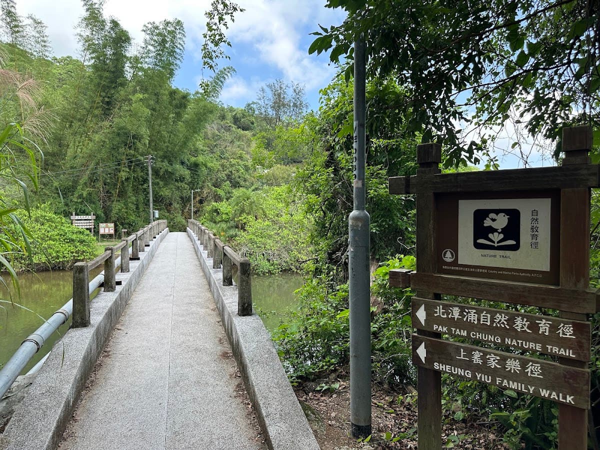
| Pak Tam Chung Nature Trail 0.9 km・30min 1 star — Easy Shade Medium | About three minutes from Sheung Yiu bus stop to Fuk Hing Bridge, then the riverside path to the Folk Museum. Retrace to the bridge to leave; 0.9 km is not the round trip. Ascent 1 / 5・Surface 1 / 5・Official map / GPX |
| Sheung Yiu Family Walk 1.8 km・75min 2 stars — Moderate Shade Medium | Approach through the Nature Trail to Sheung Yiu, then leave via Sheung Yiu or Tsak Yue Wu bus stop. The two trails total about 2.7 km, plus transport connections. Ascent 1 / 5・Surface 2 / 5・Official map / GPX |
| Pak Tam Country Trail 2 km・45min 1 star — Easy Shade Medium | Start at Pak Tam Au: about three minutes from the stop to the entrance. After finishing near Yee Ting, allow about four minutes to onward transport. Different endpoints. Ascent 1 / 5・Surface 2 / 5・Official map / GPX |
| Sheung Yiu Country Trail 3.2 km・75min 2 stars — Moderate Shade Low | About 20 minutes from Sheung Yiu stop to the entrance, then about 45 minutes along Man Yee Road from the finish to transport. Roughly 2 h 20 min including the trail, before breaks or bus travel. Ascent 1 / 5・Surface 2 / 5・Official map / GPX |
One shared feature is an ascent score of 1 for all six routes. This describes total ascent, not the absence of steep individual sections: Sheung Yiu Country Trail, for example, begins with a steep climb.
For interpreting the components, see the Hong Kong hiking difficulty guide.
Getting there: Pak Tam Chung, Sheung Yiu or Pak Tam Au?
From Sai Kung town, check KMB 94 towards Wong Shek for the relevant stop; use the Sai Kung direction on the return. Minibuses 7 and 9 serve some access points. For the Pak Tam Au start of Pak Tam Country Trail, check suitable services such as minibus 7; do not assume 9 serves every start.
- Tree Walk or Pak Tam Chung Family Walk: look for Pak Tam Chung bus stop.
- Nature Trail or either Sheung Yiu walk: look for Sheung Yiu / Fuk Hing Bridge, and allow the approach walk.
- Pak Tam Country Trail: look for Pak Tam Au bus stop. Pak Tam Au and Pak Tam Chung are different places.
Special buses have their own operating days and directional hours. Check HKeMobility and the Sai Kung hiking transport guide, including the return stop, direction and last departure. Drivers should also read the Sai Kung parking guide; nearby parking does not guarantee a space.
Pak Tam Chung also starts MacLehose Trail Section 1 and is a transfer point for minibus 9A to the East Dam. See the East Dam transport guide for operating arrangements; 9A is not needed for these short trails.
The individual walks
Pak Tam Chung Tree Walk: 0.6 km
The detailed official description gives 580 metres, rounded to 0.6 km in the table. Part overlaps a hiking practice route, with interpretation boards about trees including paperbark, Brisbane box and native species such as camphor and sweet gum.
Access: from Pak Tam Chung bus stop, allow about five minutes to the starting area by the PHAB site. Regular options include 94 and minibuses 7/9; check special-day buses such as 33R, 74R and 96R before relying on them.The end returns to the start, which simplifies returning to a parked car if lawful parking is available.
With a half-hour reference time, ascent and surface scores of 1 and high shade, it is a gentle first-walk candidate in suitable weather. Children still need supervision.
Pak Tam Chung Nature Trail: 0.9 km
This riverside route explores the meeting of fresh and salt water. Mangroves may reveal fiddler crabs and mudskippers at low tide, while interpretation introduces plants and their traditional village uses.
It leads toward the Sheung Yiu Folk Museum. The former Hakka village dates to the late 19th century and had lime and brick production. After decline and abandonment in the 1960s, it became a museum in 1984; the village and lime kiln are declared monuments. Check museum opening hours separately.
Access: from Sheung Yiu bus stop, allow about three minutes along Tai Mong Tsai Road to Fuk Hing Bridge, or use an appropriate minibus stop. Options include 94, operating-day 96R/289R and minibuses 7/9; confirm the current stops.
⚠️ Check route 289R's directional service hours before depending on it. Special services can have restricted departure windows; it is not the only route in the area with timetable limits.
Returning from the Nature Trail: the official exit instructions retrace from Sheung Yiu to Fuk Hing Bridge. Walking the trail both ways is about 1.8 km, plus the bus-stop approach. Museum visits and breaks take additional time.
Pak Tam Chung Family Walk: 1.4 km
The entrance is behind the coach parking area. Our Sai Kung family hiking guide highlights its balanced profile: 1.4 km, official 45 minutes, ascent and surface scores of 1, and high shade.
Access: start near Pak Tam Chung bus stop, using a suitable operating service. The listed exit is toward Tsak Yue Wu bus stop on Pak Tam Road for 94, operating-day 96R and minibuses 7/9. Do not assume this is a loop returning to the identical start; add any retracing needed.
Sheung Yiu Family Walk: 1.8 km
Starting around the museum, this walk combines natural and cultural interest. The former Hakka settlement includes a tower, a row of houses and a lime kiln that illustrates historical production; the museum displays traditional tools and household objects.
There are wooded views toward Tai Cham Koi, with bays, mangroves, barbecue facilities and camps in the wider area.
Access: use Sheung Yiu bus stop or Fuk Hing Bridge, then follow the Nature Trail approach to Sheung Yiu.A common combination joins the two walks: the 0.9 km Nature Trail followed by the 1.8 km Family Walk totals about 2.7 km before any additional return or access walking.
Pak Tam Country Trail: 2 km
This introductory trail follows an old village connection between Pak Tam Au and Pak Tam Chung, using earth and stone paths.
Starting at Pak Tam Au gives a mainly downhill direction. Views include surrounding hills and occasional glimpses through valleys toward Kau Sai Chau. The route ends near the Yee Ting camping area; allow for your own pace.
Access: from Pak Tam Au bus stop, walk about three minutes along Pak Tam Road toward Pak Tam Chung to the entrance. Use an appropriate 94, operating-day 96R or minibus 7 service. The listed finish has a further short walk of about four minutes to onward transport.
⚠️ The start and finish are different. Drivers need a car-retrieval plan; public transport can simplify this route.
Sheung Yiu Country Trail: 3.2 km
This option needs more attention to terrain and access than the shorter walks above.
Much of it enters woodland, but the opening climb is steep. Gaps offer views across islands in Port Shelter and High Island waters. The route passes the Pak Fu Wan campsite area near Nam Fung Wan.
Nam Fung Wan includes the site of a former Vietnamese detention centre, closed in 1998, and is now associated with the Astropark and water-sports facilities. The route finishes on Sai Kung Man Yee Road near High Island Reservoir, completed in the late 1970s.
⚠️ Allow for both access walks: from the Sheung Yiu bus stop, it is about 20 minutes on foot to the village-end trail entrance; from the finish, allow about 45 minutes along Man Yee Road toward Pak Tam Chung to the Sheung Yiu transport connection. That adds roughly 65 minutes to the official 1.25-hour trail time.
Despite wooded sections, the official shade rating is low. With approaches, breaks and the exit, plan it as a half-day outing rather than a one-hour stroll.
A common mix-up: Tsiu Hang is elsewhere
Tsiu Hang Nature Trail is 0.9 km, officially half an hour, one star and high shade, but it is not one of the Pak Tam Chung starting-area routes.
It is within the Lions Nature Education Centre. The approach uses Pak Kong in Sai Kung and a walk of about ten minutes through the centre to the area beside the herbal garden.
It uses a different set of transport connections, including KMB 92 and operating-day 96R, Citybus 792M and minibuses 1, 1A, 12 and 101M. Check current routes; 96R may serve both wider areas, so the stop matters.
The walk has host and nectar plants for butterflies, plus trees such as sweet gum, persimmon, screw pine and Chinese white olive. Wildlife sightings vary with season and conditions.
⚠️ Do not touch the Chinese lacquer tree or other unfamiliar plants. Its sap can irritate skin; supervise children closely.
How to choose
If you have only about an hour
Pak Tam Chung Tree Walk has a half-hour reference time and is the most straightforward short candidate. The Family Walk's 45-minute reference leaves less room for access and pauses. Include transport, return walking and your pace; neither promises a one-hour door-to-door outing.
For heritage
Combine the Nature Trail and Sheung Yiu Family Walk for roughly 2.7 km, plus access and return needs. Check museum opening hours if the exhibits are central to your plan.
For downhill walking and views
Pak Tam Country Trail from Pak Tam Au is mainly downhill: 2 km with a 45-minute reference time. Its different endpoints require transport or car-retrieval planning.
With children
Consider the high-shade Tree Walk or Family Walk, with time adjusted to the child. See Sai Kung family hiking routes.
⚠️ Sheung Yiu Country Trail is not the first choice for an inexperienced young family, because of its steep opening, low shade rating and roughly 65 minutes of additional approach and exit walking.
Driving
The Tree Walk returns to its start. Other walks can be planned with retracing, but count the extra distance. Pak Tam Country Trail and Sheung Yiu Country Trail have different endpoints, making a separate return-to-car plan important.
See the Sai Kung parking guide and check current road restrictions and signs around the town rather than assuming a fixed holiday rule.
Facilities and supplies
Pak Tam Chung has relatively developed visitor facilities, including a bus terminus, coach parking and the PHAB area. Check the actual location and opening of toilets or other facilities you need; a nearby camp is not necessarily open to casual visitors.
Carry water for the complete outing, delays and weather. Check any refill point beforehand; short distance does not remove heat risk.
Official route pages provide maps and, where available, GPX downloads. Save relevant information offline and see Sai Kung weather and safety conditions.
Ready for a longer walk?
Longer options from this area need their own fitness, weather and exit planning:
- MacLehose Trail Section 1 is 10.6 km and three stars, with surface score 2. Finishing at the East Dam is possible if return transport is confirmed.
- High Island Reservoir East Dam can be reached using 9A on operating days or a taxi. The East Dam trail itself is 2.8 km and one star; the road approach is additional if walked.
- Pak Tam Chung to Biu Tsim Kok Hiking Trail is 11.1 km and three stars, with ascent score 4, requiring more climbing fitness.
Compare the 31 routes selected for our Sai Kung hiking routes guide and consult the Sai Kung hiking transport guide for access.
After the walk
If returning through Sai Kung town, see the changing and shower facilities guide and Sai Kung food guide. Evening traffic and queues can be busy.
Choosing a short route may leave time for another activity if transfers, rest and weather allow. Options are in the Sai Kung water activities guide and Sai Kung one-day itinerary. Families can consider the Pak Sha Chau family kayaking trip or other family water activities, subject to current participation requirements and meeting times. For equipment, see rental services.
Official route maps and pre-trip checks
These official pages provide maps, endpoints and GPX downloads. The six route records were checked on 3 October 2026. Check current notices for closures and transport changes before travelling.
- Pak Tam Chung Tree Walk
- Pak Tam Chung Nature Trail
- Pak Tam Chung Family Walk
- Sheung Yiu Family Walk
- Pak Tam Country Trail
- Sheung Yiu Country Trail
Frequently asked questions
Is Pak Tam Chung Family Walk a loop?
The official start is behind the Pak Tam Chung coach parking area; the exit instructions lead to Tsak Yue Wu bus stop on Pak Tam Road. Do not treat the 1.4 km or 45-minute reference as a loop back to the same start. Add a return plan if your car is at Pak Tam Chung.
Does the Nature Trail’s 0.9 km include the return?
The 0.9 km is the trail towards Sheung Yiu from Fuk Hing Bridge. Retracing it as the official exit directions suggest gives about 1.8 km, plus access from the bus stop, breaks and museum time.
Can I take a stroller on Pak Tam Chung Family Walk?
A one-star hiking rating does not confirm stroller access. Check steps, slopes, surface and the full connection to public transport before using a stroller or wheelchair; the Family Walk name alone does not establish accessibility.
Are there Sai Kung walks with reference times under an hour?
Four trails have official reference times under an hour: the Tree Walk and Nature Trail at 30 minutes, and Pak Tam Chung Family Walk and Pak Tam Country Trail at 45 minutes. Add approaches, breaks and any required retracing; these are not one-hour outings including transport.
Can I visit these routes on weekdays?
Yes, regular services including 94 and minibuses 7/9 serve relevant starting areas. Check the exact stop and timetable. Special bus routes and 9A have different operating days and may have additional announced services.
Which is a good beginner option?
The Tree Walk and Family Walk both have one-star ratings, ascent and surface scores 1, and high shade. The Tree Walk returns to its start; the Family Walk's listed exit is near Tsak Yue Wu, so do not assume identical endpoints. Choose by actual time and ability.
Is Tsiu Hang Nature Trail at Pak Tam Chung?
No. It is in the Lions Nature Education Centre near Pak Kong, with different access. Check the correct stop for services such as 92, 96R, 792M and relevant minibuses rather than following directions for Pak Tam Chung.
Why is Sheung Yiu Country Trail not a first choice with young children?
Its 3.2 km includes a steep opening and has low official shade. The listed approach adds about 20 minutes and the exit about 45 minutes beyond the 1.25-hour trail reference. That is a much longer outing than the trail distance alone suggests.