
Browse hiking guides: family walks, islands, reservoirs and mountain views
Reach Sharp Island (Kiu Tsui Chau) by kaito from Sai Kung town; the crossing usually takes about 15 minutes. Choose Kiu Tsui / Sharp Island Pier for the tombolo and Pineapple Bun Rocks. For Half Moon Bay, confirm a service to Hap Mun Bay Pier.
Check that day’s sailings, tide information, return pier and last pickup before choosing your walk. Start with transport below, then compare the tide checks and two walking routes.
Sharp Island ferries: timetables, fares and arrival piers
Walk from the Sai Kung Bus Terminus area to the waterfront and confirm the exact boarding point with your operator. The roughly 15-minute crossing excludes waiting and is not a guaranteed duration for every sailing.
Where can I find the ferry timetable?
Use the Transport Department operator and fare list, then confirm your date with the chosen operator. Many listed Sai Kung–Kiu Tsui–Hap Mun Bay services are on demand. An operating window is not a fixed departure schedule or guaranteed final sailing.
Before paying, check whether the fare is one-way or return, which operator handles the return, whether another pier is allowed, and the last pickup time. Keep your ticket and the operator’s contact details. Confirm the current fare directly.
Choose a pier for your walk
| Your destination | Pier and walking plan |
|---|---|
| Tombolo and Pineapple Bun Rocks | Kiu Tsui / Sharp Island Pier on the west coast. The Kiu Tau crossing depends on tides and local conditions. |
| Hap Mun Bay / Half Moon Bay beach | Confirm a sailing to Hap Mun Bay Pier. It is a different landing point from Kiu Tsui. |
| Sharp Island Country Trail | West coast → Hak Shan Teng → Hap Mun Bay. Check return ticket validity and pickup if using different piers. |
Compare the official Country Trail route and Geopark route map. Checked 3 October 2026; the Transport Department list is dated 21 August 2026.
For the approach, see the Sai Kung transport guide and parking guide. Cars remain in Sai Kung town; your island walk may finish at a different pier. Compare other starts in the hiking transport guide.
Who is Sharp Island suitable for?
Both listed official routes are rated one star, or easy:
| Route | Length | Official walking time | Difficulty | Ascent | Surface | Shade |
|---|---|---|---|---|---|---|
| Sharp Island Country Trail | 1.9 km | 1 h | 1 star — Easy | 1 | 1 | Medium |
| Sharp Island Geo Trail | 1.4 km | 0.75 h | 1 star — Easy | 1 | 2 | Low |
The table uses the Enjoy Hiking Geo Trail and Country Trail figures. The Geopark’s April 2026 map instead suggests two hours for a 1.4 km return Geo Trail visit. Walking references and sightseeing allowances differ; add boats, waits and rests.
An ascent score of 1 does not mean a level path. The Country Trail climbs Hak Shan Teng before descending to Hap Mun Bay; choose it according to your group’s walking experience.
⚠️ Remember: the Geo Trail has low shade. Exposed coastal sections can be hot even on an easy walk. Avoid summer midday heat and adjust the plan to conditions. For the rating components, see the Hong Kong hiking difficulty guide.
Another advantage is a flexible itinerary. A short visit can focus on rocks and the tombolo, while a longer one can include the Country Trail. Allow extra time for tides, stops and ferries; boat access does not guarantee an immediate exit.
Sharp Island low tide: checking the tombolo before you go
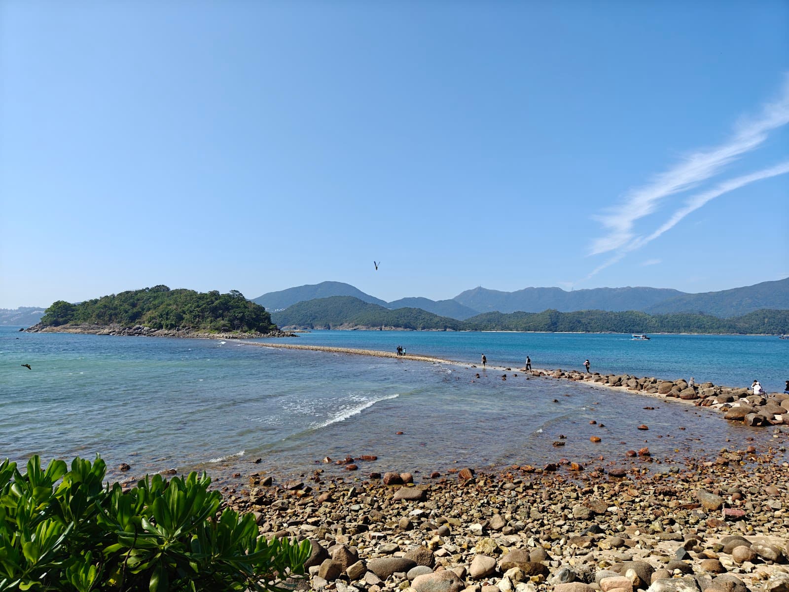
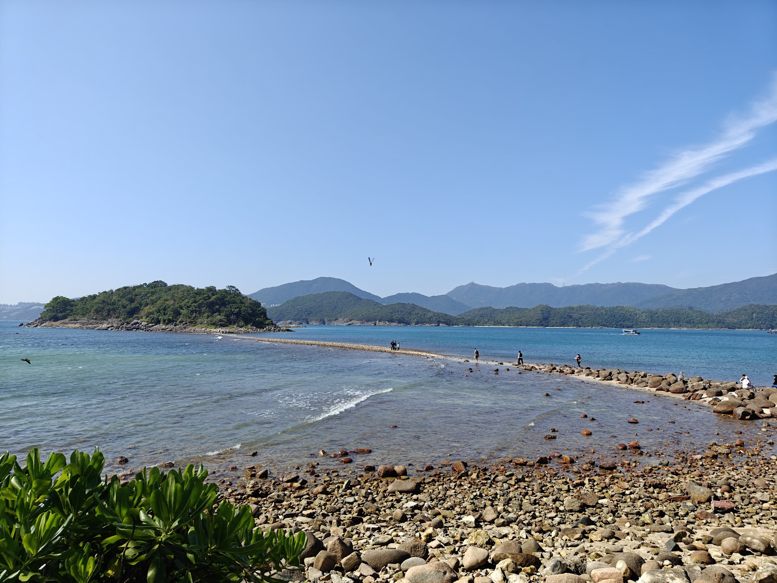
The tombolo links Sharp Island with Kiu Tau. Its exposure changes daily. A low-tide time is a single moment, not a complete crossing window. Do not reuse yesterday’s times.
Four checks before crossing
- Start with the Geopark Sharp Island page for current tombolo information, dates and notices.
- Follow its link to HKO’s Tai Miu Wan tide page. This is a reference station, not a measurement on the tombolo itself.
- For another date, use HKO’s text tide tables: choose Tai Miu Wan, the year and date, and distinguish high and low tides. Times are Hong Kong time; predictions can differ from actual water levels.
- At the island, check the information and warnings before the tombolo. Leave time to return; skip Kiu Tau if water covers the path, the tide is rising or conditions are unsuitable.
The Geopark’s 1.25 m reference is not a safety guarantee
The Geopark guidance uses below 1.25 m, while the official Enjoy Hiking Geo Trail page still lists 1.4 m. We retain the Geopark reference and do not calculate a guaranteed crossing window from either figure.
HKO’s notes explain that weather can change actual water levels. Even an exposed tombolo requires attention to waves, footing and the return journey. Do not wade through a rising tide.
Our tide and tombolo page is another planning entry point. Distinguish station data from Geopark-published exposure periods, and check the selected date, source and local conditions.
What if the tide does not suit your visit?
Subject to weather and boats, explore accessible parts of Sharp Island’s shore and beaches or choose the Country Trail. Kiu Tau has no normal alternative pedestrian exit once the tombolo is submerged. Do not cross without time to return.
Routes and highlights
The official Geo Trail starts at Sharp Island Pier and passes the beach and tombolo toward Kiu Tau; the crossing section is tide-dependent.
Around the pier
The managed bathing beach is beside the pier. Nearby natural outcrops show a mixture of volcanic materials, including ash, rock fragments and lava-related deposits.
Pineapple Bun Rocks
Boulders near the beach and tombolo include rhyolite and quartz monzonite. Some have cracked, weathered surfaces resembling Hong Kong pineapple buns.
Weathering produces the distinctive outer texture. These much-photographed rocks are a useful landmark near the tombolo approach, but do not climb on or damage them.
Kiu Tau and the viewpoint
When the crossing and path are safe, Kiu Tau offers a view back along the tombolo and across Port Shelter. Keep the return tide window in mind rather than lingering for a photograph.
Sharp Island is about 2,500 metres long and 500 metres wide, with its highest point around 136 metres above sea level.
Geology: part of an ancient volcanic system
Despite its small size, Sharp Island contains several igneous rock types, including volcanic breccia, tuff and rhyolite.
Geological interpretation places it within the High Island supervolcano system. Its varied rocks record an earlier phase of volcanic activity, around 143 million years ago, while the High Island Reservoir columns represent a later eruption phase.
The rocks here help explain a different stage of the same volcanic story. For the dramatic hexagonal columns, choose another route in the area.
Where the beaches actually are
Beach names around Sai Kung are easily confused. Check the island and access route, not just a familiar beach name.
| Beach | Location | Notes |
|---|---|---|
| Beaches beside Sharp Island Pier | West side of Sharp Island, by the pier | Managed facilities nearby; often busy |
| Hap Mun Bay / Half Moon Bay | Sharp Island | Beach at the southern end |
| Long Mong Wan | Northeastern Sharp Island | Remote shore with limited facilities; do not assume a maintained walking route |
| Whisky Beach | Kau Sai Chau, not Sharp Island | Sometimes incorrectly described as a Sharp Island beach |
⚠️ Whisky Beach is on Kau Sai Chau—the island with the golf course—not Sharp Island. Access requires its own planning. See the Kau Sai Chau guide.
Long Mong Wan is on the northeastern side of Sharp Island. Do not improvise a coastal scramble from the pier; confirm a suitable access route, carry supplies and plan the return boat. For other options, see seven Sai Kung beaches.
What to bring
Water, food and sun protection are particularly useful here:
- Water and food: island supplies are limited; do not depend on finding an open shop.
- Sun protection: the Geo Trail has low shade and exposed coastal sections.
- Footwear: choose secure shoes with good grip. Easy ratings do not make wet rocks or a tidal crossing non-slip.
For a water activity, protective clothing can complement sunscreen. See the water-sports sun-protection clothing guide and check Sai Kung weather and safety conditions.
The official route pages may offer a brochure, suggested route map or GPX download. Check the specific page and save an offline map; do not assume every route has every file type.
Plan the return before adding another activity
Work backwards from your confirmed pickup, allowing time to reach the correct pier, wait and absorb delays. The tombolo may require an earlier return. Do not simply add the two listed walking times and book an immediately following afternoon activity.
If you want a guided water activity, consider the Sharp Island kayaking and snorkelling experience. Confirm its mainland meeting point, timing and transport separately; being near the same island does not mean you can join directly from a hiking finish. For independent equipment options, see rental services.
For a broader plan, see the Sai Kung one-day itinerary and Sai Kung water activities guide.
Back in Sai Kung town, consult the changing and shower facilities guide and Sai Kung food guide.
Frequently asked questions
Is there a fixed Sharp Island ferry timetable?
Many relevant services in the Transport Department list operate on demand. A company’s operating hours are not an island-wide timetable. Check the official operator and fare list, then confirm the actual sailings and final pickup for your date.
Where can I check Sharp Island low tide?
Start with the Geopark Sharp Island page and its HKO Tai Miu Wan link. For other dates, use the HKO text tables with the correct station, year and day. Confirm warnings and return conditions on site.
When can I cross the tombolo?
It varies daily. The Geopark uses below 1.25 m as a reference, but you must also check current information, exposure, warnings and time to return. A low-tide time or another station’s reading does not guarantee safe passage.
Is hiking on Sharp Island difficult?
Enjoy Hiking rates both routes one star: the Country Trail is 1.9 km with a one-hour reference; the Geo Trail is 1.4 km with a 45-minute reference. The hill trail still climbs and descends. The Geopark map suggests two hours for a Geo Trail visit; allow separately for boats, rests and tides.
How do I reach Sharp Island?
Take a kaito from Sai Kung town, usually about 15 minutes on the water. Use Kiu Tsui Pier for the tombolo or confirm Hap Mun Bay service for Half Moon Bay. Check boarding, fare, return pier and last pickup before buying.
Is Whisky Beach on Sharp Island?
No. Whisky Beach is on Kau Sai Chau. Sharp Island has the beach by its pier and Hap Mun Bay, while Long Mong Wan is a remote northeastern shore with separate access considerations.
Is the island worth visiting outside the tombolo window?
Yes, if weather and transport permit. Visit accessible trails, beaches and rock viewpoints without crossing to Kiu Tau. Never cross without enough return time or wade through a submerged tombolo.
Related articles
- Sai Kung hiking routes: compare 31 walks by time, difficulty and shade
- Understanding Hong Kong hiking ratings: stars, ascent and surface
- Sai Kung hiking transport: services, holiday limits and extra walking
- Kau Sai Chau guide
- Seven Sai Kung beaches
- Sai Kung one-day itinerary
- Sai Kung water activities guide